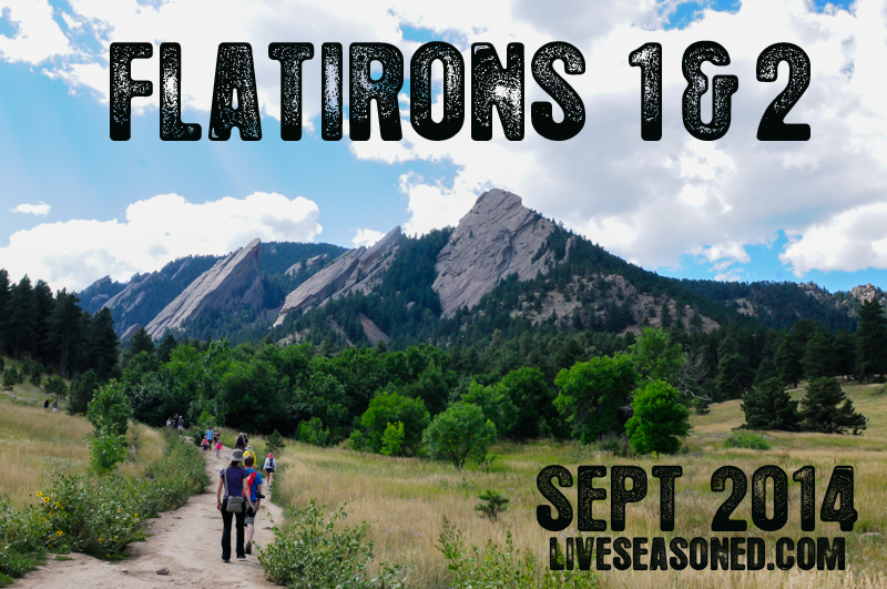
About a month ago, Katie, Jeff (our brother) and I hiked the Flatirons 1 & 2 trail. I’ve been meaning to write this post for some time since it was one of the most scenic hikes in Boulder, CO, so here goes:
The hike starts at the Chautauqua Park trailhead. Parking in the lot can be pretty tricky, especially on the weekends, but you can find additional parking on Baseline Road. That being said, the trail is extremely crowded. You won’t have the views to yourself, but hey, at least there is no chance of getting lost. After you find a parking spot, continue to the Chautauqua Park trailhead where the trail takes you through a lovely green meadow. (Note that if you’re hiking right after a rainstorm, it will be pretty muddy since the trail is basically a path for runoff water. ) The Chautauqua trail connects with the Flatirons 1&2 trail and the signage is very clear as is the flow of people flocking to the Flatirons 😉
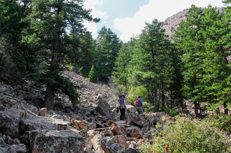
Over the course of this relatively short hike (about 2.5 miles), you will climb 1,400 feet in elevation. Flatiron 1 is approximately 7,100 ft high, which makes for stunning views. As you hike up the trail, there are plenty of outcroppings that are perfect for taking a break and enjoying the vistas. The Flatiron trail is mainly switchbacks through thick forests of ponderosa pine that cut around enormous boulders. Along the way, there are also several rock climbing access points. Speaking of climbing, there is a very short section of the trail (about 15 feet) where you have to climb up a boulder. There are footholds and handholds worn into the rock making it easy for adults, but I wouldn’t recommend taking children on this hike. I would also turn back immediately if it starts to rain because the rocks will become slippery making a large portion of this trail fairly dangerous.
Once you finally wind up, up and up, the views are spectacular. There are clear views of the city of Boulder as well as amazing views of Flatiron 3, which is sure to have rock climbers scrambling up it. The top of the trail is a perfect spot to stop and have a snack or a picnic, but remember to hike all your waste out with you, even banana peels! The top of the trail is like an adult jungle gym. You’ll see folks in all different nooks and crannies. It goes without saying that you should be careful when you’re climbing from boulder to boulder, don’t knock into any rocks that may fall and injure someone at a lower elevation. After you’ve climbed your heart out and took a bajillion pictures, it’s time to make your way down the ridge. Be mindful of other hikers who are still making their way up and if they look like they need encouraging remind them that they’re almost there!
Geology Rocks! I say that far too often, but I just can’t resist. Here’s a quick rundown of some geological properties of the flatirons. I’m going to give some definitions in case you slept through your geology lab class.
- A flat iron is a steeply sloping triangular landform created by the differential erosion of a steeply dipping, erosion resistant layer of rock overlying softer strata. Differential erosion is erosion that occurs at varying rates, caused by the differences in the hardness and resistance of surface materials so softer and weaker rocks erode rapidly, while harder rocks remain to form ridges, mountains, or ding, ding, ding, flat irons! Strata is simply sedimentary rock. Sedimentary rocks are those formed by the deposition of material either on the earth’s surface or in water. And wouldn’t you know it, the Flatirons of Boulder coined this term, flatiron, in general geology.
- Now you may be wondering how the Flatirons first got their name, which then coined the geography term. Well, there are two theories: the rock faces close resemblance to old fashioned clothing irons or their resemblance to the Flatiron building in NYC, which was completed in 1902. (It’s a pretty sweet building, but personally, I think it’s more likely they were named after the clothes iron, an object which many more folks were familiar with during the early 1900s)
- The flatirons are made up of conglomerate sandstone of the Fountain Formation. Conglomerate sandstone basically means there are little clasts (bits of rock particles) mixed into the sandstone (rock comprised mainly of sand-sized minerals or rock grains). I don’t want to wind way down into a geological rabbit hole (for your benefit), but the Fountain Formation is a Pennsylvanian (the subsystem, not the state) bedrock unit found in Colorado and Utah that consists mostly of conglomerate sandstone or arkose.
- The flatirons are estimated to be 290-296 million years old and they were tilted to their current orientation (the steep dip I referenced earlier) about 35-80 million years ago during the Laramide orogeny. The Laramide orogeny was a period of mountain building in western North America, which created the Rocky Mountains along with many other formations. I won’t go into right now, but it’s definitely interesting; if you like geology and want to learn more, read this.
What to expect:
- Lots of hikers on the weekend.
- Dogs both on and off leash.
- Plenty of wildflowers, various vegetation and trees and beautiful views.
- Two hours (or more) of hiking.
- A couple tough climbs over boulders, but mainly a moderately steep and well-maintained trail.
Before of after your hike, be sure to stop by the historic ranger cottage near the parking lot – you can’t miss it. It has a wealth of information, free maps and dozens of stuffed birds and mammals. I really enjoyed the station because I gained a better sense of what animals were sharing the forest with me. It’s especially cool to see the animals you have very little chance of seeing in the wild like mountain lions, coyotes, and bobcats. If you want a little snack, continue past the ranger station for about a block and you’ll see a little refreshment cottage with homemade hard ice cream and just about everything else.
After the hike and the ice cream, you should probably treat yourself to an afternoon snooze! Happy hiking!